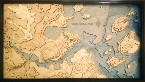
A couple months ago, I was on the internet and ran across Below The Boat, a website that sells wooden topographical maps of interesting lakefloors and seafloors around the world. Now, something you should know about me is that my family loves maps. My parents have nautical charts up on the walls in several rooms of the house, whenever I move states I get fold-out roadmaps of that state as gifts, and the first thing I got for my new apartment out of college was a big 5-foot map of the world to hang above my desk. So as you can imagine, when I ran across this idea I immediately decided that I had to make one. Christmas was coming up, so what better than to make my family a map of our hometown of Portland, ME?
I drew inspiration from Below the Boat (which shows the shape of the seafloor with flat land), this reddit post (which showed the shape of the land with flat water), and this beautiful table. With the idea in mind, I set off down a rabbit hole of cartography websites to figure out how the hell I was going to do this.
The design and build process that I came up with are too long to throw into one post, so I broke them out into a separate two post how-to guide. These should give you enough detail and direction to be able to make your own if you want to.
- Part 1: The Design Phase
- Part 2: The Build Phase
In the end, I’m incredibly happy with how it turned out, and the family loved it! Here are some more pics of the finished product. Click on them to enlarge.
And as a side note, if anyone has a laser cutter they’re not using any more and that they’d be willing to part with for ≤$2k, I’m looking for one! I promise to do cool stuff with it.
Update: Wow, after an overwhelmingly positive response on reddit, I’ve decided to spin this up into a side business doing custom maps on commission. It will take some time to set up, but if you want to hear when launch happens go ahead and throw your email on strataforma.com (my working name for now).


Reminds me of the opening credits for Game of Thrones!
Hey man very cool, I would suggest you check our Glowforge for your laser cutting needs, might be just what you need.
Glowforge looks great, but I feel iffy shelling out 2.5k+ for a preorder. Now if you have any sitting around that can ship out immediately that’s a different story…
Pingback: Links 12/28/15 | naked capitalism
Thanks for the info. I downloaded Qgis but haven’t been able to get my file to it. I found my chart on the NOAA site. What format was your dem file? Thanks.
Once I downloaded the dem zip file from the state’s website, the actual data was an .asc file.
Hello fellow Mainer!! You are just the person I need for this job! have a project I need your help on Scott or I’m wondering if I could hire you for
Please email me and I will forward you additional contact info if you can help out l
Pingback: Laser Cut Map Taken to the Next Level | Hackaday
Pingback: Laser Cut Map Taken to the Next Level | KnowNaija
Very cool, always knew my nephew was a genius.
Pingback: Want to Make a Topographical Map? This Artist Shows You How | Make:
Pingback: Make: Japan | 立体等高線地図の作り方
Pingback: Want to Make a Topographical Map? This Artist Will Show You How — Viral Pie
Pingback: Linkdump: February 2016 | 19hertz
Pingback: Singing For Her
Looks amazing, really inspired me to make something similair myself
Pingback: Made at DSL: laser cut topographical map | Dim Sum Labs